Most suburban infrastructure is designed around a simple assumption: You are currently in a car, you wish to remain in the car, and any attempt to leave the car indicates either mechanical failure or suspicious behavior.
The Illinois Prairie Path is a 61-mile rebuttal.
It slips through Cook, DuPage, and Kane Counties, passing houses, parks, wetlands, downtowns, utility corridors, road crossings, old railroad artifacts, and the occasional cyclist dressed as though the Tour de France has added a Wheaton stage. It is used by walkers, runners, bicyclists, equestrians, bird-watchers, commuters, families, and people who told their spouse they were “just going out for a quick ride” four hours ago.
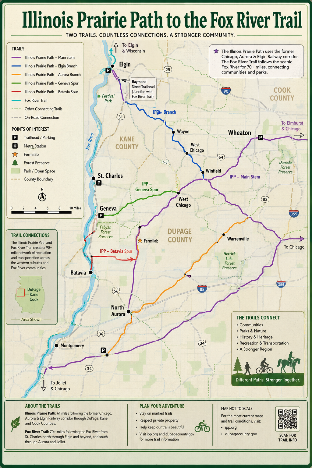
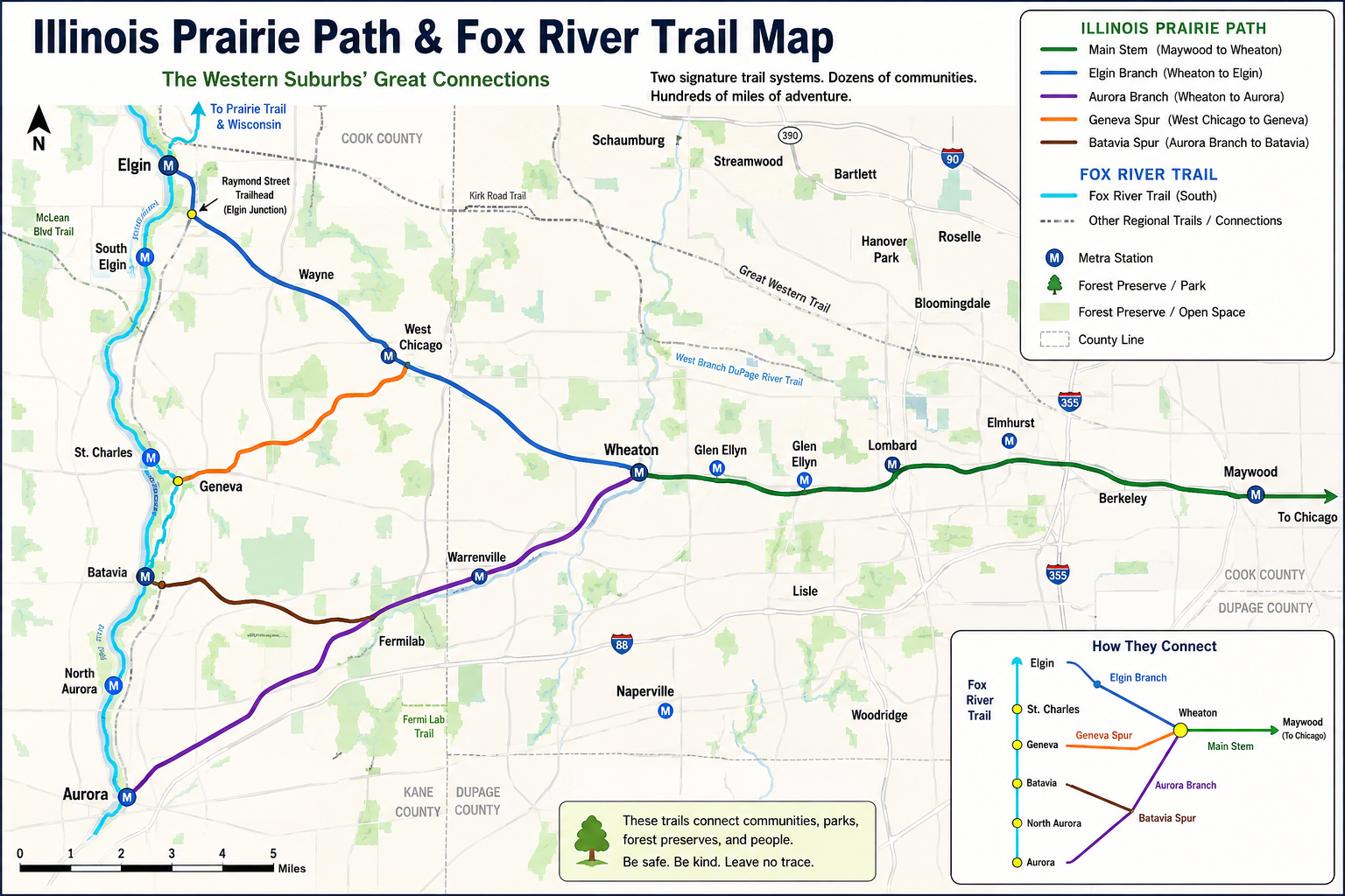
On a map, the Prairie Path looks like an inverted Y. Its Main Stem extends west from the Maywood area to Wheaton, where it splits toward Elgin and Aurora, with additional spurs connecting toward Geneva and Batavia. This is not an aesthetic flourish by the cartographer. The shape comes from the path’s former life as the right-of-way of the Chicago, Aurora and Elgin Railway, an electric interurban railroad that once carried passengers and freight between Chicago, the western suburbs, and the Fox River communities.
In other words, the Prairie Path was not created because suburban planners gathered around a table and asked, “How can we make it pleasant to move through the region without purchasing gasoline?”
It exists because a railroad died.
And because one woman looked at the corpse and saw a trail.
The map is really an X-ray
A normal trail map tells you where to turn. The Illinois Prairie Path map tells you what the western suburbs used to be.
The route follows the abandoned Chicago, Aurora and Elgin corridor. The railway suspended passenger service in 1957, ended freight operations in 1959, and formally abandoned the right-of-way in 1961. Its trains disappeared, but the long, narrow strip of land remained—a transportation system with the transportation removed.
This is one of history’s recurring habits. We build something enormous around a technology, the technology becomes obsolete, and then everybody stares at the leftover structure as though an extinct civilization placed it there.
Railroad corridors are especially useful ruins. They are relatively straight. They connect communities. Their grades are gentle because trains, despite their many talents, are not enthusiastic mountain climbers. They cross rivers and roads. They already form networks.
A disused rail corridor is therefore not merely empty land. It is a complete answer waiting for somebody to ask a different question.
That somebody was naturalist and educator May Theilgaard Watts.
On September 30, 1963, the Chicago Tribune published her letter advocating for a public path along the abandoned railway. The public response was immediate. The institutional response was what institutional responses usually are when someone presents an excellent new idea: a maze of ownership questions, legal complications, government jurisdictions, financial problems, and meetings in which someone almost certainly said, “We’ll have to form a subcommittee.”
Watts and the other early advocates were not simply proposing a place to ride bicycles. They were proposing a new mental category.
At the time, an abandoned railroad was understood mainly as failed industrial property. Watts reframed it as a linear nature preserve, recreation corridor, outdoor classroom, and safe transportation route. The steel rails could disappear without the connectedness disappearing with them.
That shift sounds obvious now because successful ideas eventually acquire the irritating appearance of inevitability. Of course an abandoned railroad can become a trail. Of course people would use it. Of course communities would benefit.
But “of course” is what we say after somebody else has spent several years being treated as unreasonable.
The first construction material was stubbornness
The Prairie Path did not spring fully formed from a professionally branded regional plan with a launch event, stakeholder breakfast, and commemorative reusable water bottle.
Fourteen founders organized a board, recruited supporters, contacted officials at multiple levels of government, built a grassroots campaign, and worked through the fragmented ownership of the former rail corridor. In 953 days—about 2.6 years—they secured a 12-year lease from DuPage County allowing 27 miles of the corridor to be developed as a public path.
They had permission.
They did not have money, construction materials, or meaningful government assistance.
This distinction will be familiar to anyone who has ever been told, “Management fully supports the initiative,” moments before discovering that management has allocated zero dollars and would also like the initiative completed by Thursday.
Volunteers began clearing the route themselves. Individuals, families, schools, Scout troops, businesses, neighborhood groups, and public works crews removed tons of rubbish. Communities donated limestone screenings and labor. Bridges had to be built. Vegetation had to be managed. Sections needed continual maintenance.
By 1971, volunteers had adopted 19 of the original 27 miles—roughly 70 percent of the path. That same year, the U.S. Department of the Interior designated it a National Recreation Trail, the first trail in Illinois to receive that recognition.
The chronology matters. Recognition followed the work.
Today we often discuss public improvements as though the primary requirement is finding the perfect policy language. The Prairie Path began with a letter, but it survived because people picked up garbage, hauled stone, cleared brush, raised money, negotiated leases, repaired damage, and returned after setbacks.
One bridge over the East Branch of the DuPage River reportedly had to be replaced six times because of flooding and vandalism. Six times. After the third bridge, most reasonable people would have begun referring to the river as “the winner.” The volunteers kept rebuilding.
That is the unphotogenic secret behind most beloved civic spaces. We admire the finished trail and imagine that the decisive moment was the original vision. Vision mattered. But vision without maintenance is simply a picturesque form of abandonment.
A path is not one thing
The Prairie Path’s map appears simple until you try to describe what the path actually does.
The Main Stem passes through communities including Maywood, Berkeley, Elmhurst, Villa Park, Lombard, Glen Ellyn, and Wheaton. From Wheaton, the Elgin Branch heads northwest through areas such as Lincoln Marsh, West Chicago, Wayne, and South Elgin. The Aurora Branch runs southwest through Warrenville and toward Aurora. The Geneva and Batavia spurs extend the network toward the Fox River. Along the way, the path connects with other major routes, including the Fox River Trail and the Great Western Trail.
This makes the Prairie Path less like a single recreational trail and more like connective tissue.
A person can use one section for a neighborhood walk. Another can ride a 25-, 30-, or 40-mile loop by combining its branches with connecting trails. The official map even identifies a series of popular triangular routes, including circuits linking Wheaton, Geneva, Batavia, Aurora, Elgin, West Chicago, and Villa Park.
The word “trail” can undersell this.
A trail sounds optional, perhaps decorative—a place to visit after the real transportation system has taken you there. But the Prairie Path connects downtowns, residential neighborhoods, parks, forest preserves, schools, commuter rail areas, and regional trail networks. It can be recreation, transportation, exercise, habitat, history, and community space within the same mile.
We prefer categories because categories make budgeting easier. A road is transportation. A park is recreation. A classroom is education. A habitat is conservation. The Prairie Path is inconveniently all of them.
This may explain why linear trails provide such unusual value. A traditional park is a destination. A trail is both a destination and a way to reach other destinations. It does not merely occupy space; it organizes space.
It changes the perceived distance between places.
Two towns separated by traffic, stoplights, and multilane roads can feel far apart. Put them on the same continuous trail and they become neighboring chapters.
The humble genius of crushed limestone
Most of the Prairie Path is surfaced with crushed limestone, a material that does not inspire dramatic architectural renderings.
No one stands before a room of investors and declares, “Ladies and gentlemen, behold: screenings.”
But the surface is central to the trail’s identity. It is relatively forgiving for runners and walkers, workable for bicycles, and able to shed water after rainfall. It also preserves a sense that the route is a path rather than simply a narrow road from which automobiles have been temporarily excluded.
That balance is harder to achieve than it looks.
Public spaces frequently become victims of improvement. We discover something people like, then begin adding features until we have eliminated the quality people liked. A quiet path becomes an amenity corridor. An amenity corridor becomes an attraction. The attraction receives larger parking lots so more people can experience the serenity.
The Prairie Path works partly because much of it remains modest. It does not constantly demand attention. It passes behind homes, under power lines, beside parks, through prairie restorations, and across busy streets. Some stretches are scenic. Others are utilitarian. Occasionally the view is less “untouched Illinois landscape” and more “rear loading area of a regional plumbing supplier.”
But continuity is its own beauty.
The path does not need every mile to be extraordinary. It needs every mile to connect to the next one.
That principle applies well beyond trails. We routinely overvalue peak experiences and undervalue systems that make ordinary experiences consistently possible. The spectacular bridge gets photographed. The unremarkable mile that safely connects a child’s neighborhood to that bridge is what makes the bridge useful.
The suburbs have a memory problem
Drive through the western suburbs and the landscape can appear almost entirely contemporary: subdivisions, arterial roads, parking lots, commercial strips, office parks, and signs advertising luxury apartments located beside six lanes of traffic.
The Prairie Path reveals an older skeleton underneath.
Railroad spikes appear in its emblem, arranged in the inverted-Y shape of the trail. Old bridges, culverts, signal bases, grades, and other railway remnants still survive along portions of the former right-of-way. Even where the physical artifacts are difficult to spot, the route itself is an artifact hundreds of feet wide and dozens of miles long.
This is history at human speed.
A historical plaque asks you to stop and read. A historical corridor lets you move through the old logic of the region. The railway once determined where people traveled, where communities developed, and how goods moved. The path now carries different users, but it still performs the railroad’s most basic function: linking places that would otherwise feel separate.
The transformation also complicates our idea of preservation.
Preserving the corridor did not mean freezing it in 1957, keeping trains running forever, or turning all 61 miles into an outdoor railway museum. The path preserved the route by changing its purpose.
Sometimes the only way to save a useful piece of the past is to stop insisting that it remain what it was.
Success is what makes the original idea disappear
Expansion continued during the 1970s. Agreements extended the path west toward the Fox River through the Elgin and Aurora branches and the Batavia Spur. In 1979, eastward expansion was approved through several Cook County communities.
Then came one of the most Prairie Path stories imaginable.
In 1982 and 1983, volunteers undertook the construction of a bridge in Wheaton. Professional bids exceeded $250,000. Volunteers completed it for about $25,000, aided by donated materials and welding performed by area vocational students.
This does not mean every bridge should be constructed by whoever happens to be free Saturday morning. It means the Prairie Path repeatedly advanced because people refused to accept the first available definition of what was practical.
In 1986, amid a national liability-insurance crisis, the nonprofit lost its coverage. DuPage County took over maintenance of the path, while the Illinois Prairie Path organization continued concentrating on advocacy, recreation, prairie restoration, conservation, land preservation, and historical interpretation. Today, different portions are maintained through a patchwork of county agencies, park districts, municipalities, and volunteer support.
The path is now so established that it can feel like a naturally occurring feature of Illinois, perhaps deposited by a glacier shortly after the creation of Jewel-Osco.
That is what successful civic imagination often looks like after several decades. The struggle vanishes from view. Children grow up assuming the trail has always been there. Homebuyers describe living near it as an amenity. Runners complain about road crossings. Cyclists debate surface conditions. Municipalities print it on maps.
The impossible idea becomes infrastructure, and infrastructure becomes background.
Which is both the triumph and the danger.
When something valuable begins to look inevitable, we stop noticing that it depends on continued choices: to maintain it, connect it, protect it, restore its landscapes, improve dangerous crossings, pick up the trash, and resist slicing the corridor into pieces whenever a more profitable short-term use appears.
The Illinois Prairie Path began when May Theilgaard Watts looked at an abandoned railway and imagined people moving through it again—not sealed inside a train this time, but walking, riding, observing, and exploring.
Everyone else saw the end of a line.
She noticed it still went somewhere.
You must be logged in to post a comment.